Skip to content
Sparton-Satellite-Communications-web

Antenna Positioning

Inertial Sensors Solutions

Overview

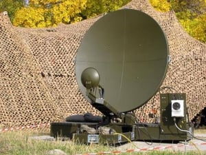
Whether your product is intended to be used in defense or civilian applications, the performance of today’s leading edge communication systems are demanding efficient, reliable and accurate antenna positioning. In either portable or permanent system installations, RF and SATCOM systems require high antenna pointing accuracy at all times and under extreme environmental conditions.

Azimuth and elevation angles are vital components for accurate antenna positioning and optimum system performance. The complex nature of communication systems presents significant challenges to obtaining maximum accuracy- reliably, quickly, and repeatedly. Manual antenna pointing and alignment can be cumbersome and time consuming for your customer. Since most systems measure the earth’s horizontal magnetic field to determine heading, unwanted magnetic disturbances, whether intrinsically produced by hard and soft iron components on the antenna platform, or from transient external sources cause errors in the heading output of conventional analog or digital magnetic compasses.

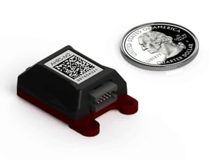
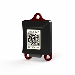
A complete system integrating MEMS inertial sensors, magnetometers, and algorithms to process and manage sensor data is required to overcome the difficulties of this challenging application. For many applications this must be accomplished cost effectively within a small, lightweight package with minimal power demands on the system.

Key Benefits

Sparton understands the complexity, challenges, and requirements of antenna positioning systems. Our line of sensor systems offers a complete and integrated solution that not only outputs accurate magnetic azimuth/heading and platform attitude data, but much more:

  • State-of-the-art tri-axial magnetometers augmented with tri-axial MEMS accelerometers and gyros correct for antenna platform tilt and motion.

  • Tri-axial gyros also provide heading stability in the presence of transient magnetic disturbances; e.g., a motor vehicle passing in close proximity to the antenna system.

  • Calibrated sensor data can be streamed from the system, eliminating the need for an additional IMU.

  • Our proprietary AdaptNav and AdaptNav II sensor fusion algorithms provide real-time optimization of sensor performance in varying magnetic and dynamic operating environments.

    In addition, AdaptNav II provides real-time platform “noise” characterizations used for drift compensation of heading, pitch and roll when in electrically and mechanically “noisy” environments.

  • Our one-of-a-kind NorthTek embedded programming platform provides limitless output customization as well as additional processing capability that can be utilized for other system processing requirements. Think of it as having the ability to write, download, and run custom apps for your antenna positioning system.

  • Sparton’s sensor systems can also be arbitrarily mounted on the platform and easily “tared” or “bore sighted” in the field to a true north heading or even a known satellite position.

  • Simple, fast, in-field calibration ensures rapid system availability and maximum accuracy.

  • Multiple data outputs for calculation of figure of merit (FOM) for heading accuracy and quality of calibration.

  • Optional “strap down” mounting configurations: ruggedized mount with USB cable or lightweight, precision mount with configurable ribbon cable allowing for flexibility and highly accurate mechanical positioning on the antenna system platform.

All this in a package that is less than 0.8 in3, weighs 16g, and consumes only 330 mW. This is not a conventional magnetic compass! It is an affordable “state of the art”, integrated sub-system that provides heading, azimuth and inertial data outputs while minimizing size, weight, power and cost.

bg_cta_schedule

Have a Challenge?

We can help. Schedule a quick one-on-one call with
specialists from our Sales and Engineering teams.